
Have you ever wondered how people who lived before the invention of air travel and satellites created maps? The simple answer is this: Ancient cartographers from around the world relied on a mix of art, exploration, mathematical skills, and a heap of imagination to illustrate the breadth of the land they knew and believed to be.
This answer may not be satisfactory for some, but it is indeed simple. Today, we are used to rapid new understanding and developments in technology and information, but the history of map making is much slower. Ancient maps are the product of successive generations of travelers, explorers, geographers, mathematicians, and cartographers. Therefore, the early studies were based on some realistic measurements as well as a lot of speculation.
The first detailed map of the “known world”
One of the first detailed descriptions of the “known world” was made by Anaximander, considered one of the seven sages of Greece. Here we underline the phrase “known world” because Anaximander’s circular map showed the territory of Greece (at the center of the world) and then parts of Europe, South Asia and North Africa. For Anaximander these continents were connected in a circle surrounded by water. More importantly, the earth was considered flat.
However, this did not stay the same for long. B.C. In the first century BC, Eratosthenes of Cyrene, a Greek polymath, was able to calculate the circumference of the planet by comparing the results of extensive research collected in the Library of Alexandria. While many people believed the Earth was round before this, we don’t have records of how they tried to measure its circumference, but in this example we do.
Eratosthenes’ method was simple and could be practiced by anyone today. He measured the length of the shadow cast by a vertical bar in two cities on the same day. He then developed a ratio from the north-south distance between the two cities, whose angles allowed him to calculate the size of the Earth.
Eratosthenes also developed a way to more accurately locate places. He used a grid system that divided the world into pieces. He also divided the known world into five climatic zones; two temperate zones, two frozen zones to the north and south, and a central tropical zone encompassing the equator. When all these features come together, a much more sophisticated map has emerged that provides a detailed representation of the world.
Maps are getting more sophisticated
In the centuries that followed, maps became more sophisticated as Roman and Greek mapmakers continued to gather information from travelers and armies. The corpus of measurements and calculations they produced enabled him to produce Claudius Ptolemy’s highly influential eight-volume Geographia and the maps that followed. Ptolemy was another polymath who wrote some of the most influential scientific texts of his age, many of which were used by later Islamic and European scholars for centuries.
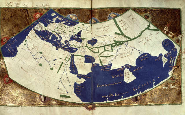
Ptolemy’s work, compiled around 150 AD, was also largely based on ancient sources and compiled material. But what makes it more effective is the step-by-step explanation of how he does it so that others can imitate his techniques. Also, Ptolemy’s Geographia was filled with detailed coordinates of all the places he knew, and he invented the idea of latitude and longitude that we still use today.
…and the compass is invented
An important development in the history of cartography and map making was the invention of magnetic compasses. Although knowledge of magnetism is much older, its use in devices that could be used for navigation was not adopted until the 13th century. This was followed by the creation of the portolan map, a nautical guide that travelers use to navigate between ports. These maps are designed to be viewed from all angles, using wind rose lines extending from central points.
A wonderful example of a rich and detailed portolan map, the Catalan Atlas was created for King Charles V of France by cartographers with information gathered from various sources. It is not clear exactly who made the map, but it is usually based on Abraham Cresques and his son Jahuda, who were part of the Mallorcan school of cartography.
The Catalan Atlas is both a portolan map and a thematic representation of the world as imagined. Although it is full of details of real places, it also includes many fantastic features. As such, monsters, dragons, sea monsters, and putative landmasses continued to appear on many maps long after their creation.
However, with a process of control and refinement over the ensuing centuries, maps became increasingly sophisticated and useful even before airplanes or satellites were invented. It just took so long.


