
 AFAD Earthquake Department has published a preliminary assessment report on earthquakes, the epicenter of which is Pazarcık and Elbistan districts of Kahramanmaraş. As it is known, on February 6, an earthquake with a magnitude of 7.7 and then 7.6 occurred in Kahramanmaraş and millions of people were affected.
In the preliminary evaluation report of AFAD, it is stated that around 1300 aftershocks occurred between 6 February and 9 February. The report states that the 7.7-magnitude earthquake occurred at a depth of 8.6 km, and the 7.6-magnitude earthquake occurred at a depth of 7 km.
General information about the earthquake
| 06.02.2023 04:17:34 (TSI), Pazarcık (Kahramanmaraş) Earthquake MW 7.7 | ||
|---|---|---|
| Latitude: 37,288 | Longitude: 37,043 | Depth: 8.60 km |
| 06.02.2023 13 7 :24:47 (TSI), Elbistan (Kahramanmaraş) Earthquake MW 7.6 | ||
| Latitude: 38,089 | Longitude: 37,239 | Depth: 7 km |
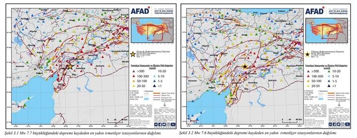 In the preliminary report of AFAD, the 7.7-magnitude Pazarcık earthquake points to the Narlı Segment at the northern end of the left-lateral strike-slip Dead Sea Fault Zone, and the 7.6-magnitude Elbistan earthquake to the Çardak Fault, a branch that separates from the East Anatolian Fault.
In the report, it is stated that 224 earthquakes, the largest of which was 6.0, occurred in the region from 1900 to 06.02.2023, and there were 75 historical earthquake records for the pre-1900 year.
Earthquake hazard and severity of the region
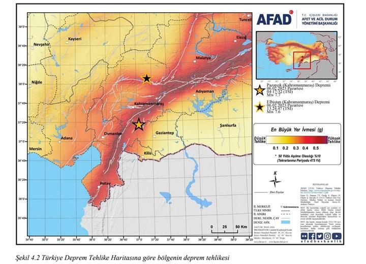 In the map published in the report, it is clearly seen that the areas where earthquakes occurred are already in the high danger zones in the earthquake risk maps.
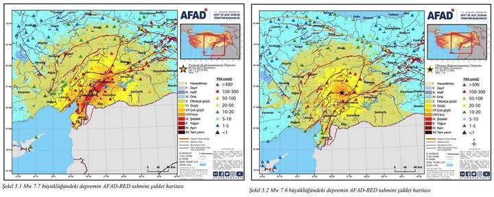 According to the intensity map produced using the Earthquake Preliminary Damage Estimation System (AFAD-RED), the intensity of the destruction caused by the 7.7-magnitude earthquake in the settlement is expressed as “Extreme”, and the intensity of the earthquake with a magnitude of 7.6 is expressed as “Intense”. According to the scale, the level expressed as “Extreme” is just below the peak severity expressed as “Total destruction”. This shows the intensity of the earthquake, that is, the extent of the damage.
Stress situation of the region
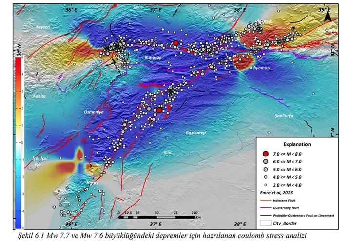 According to the Moment Tensor solution, the coulomb stress in the region was also calculated using earthquakes whose magnitudes were calculated as 7.8, 7.6 and 6.7. The following statements were included in the calculations:
In the region between the intersection of the East Anatolian Fault (DAF) and the Bitlis-Zagros Thrust Zone and the Malatya Plain, 4-5 bars; 4-5 bars on the Çelikhan-Erkenek segment of the EAF just southwest of the intersection; The tension, which started with 5 bars in Göksun (Kahramanmaraş), continues to decrease to 1 bar towards the west; It has been observed that there is a voltage accumulation in the range of 1-4 bar in the Iskenderun Bay.
Finally, let us state that the data in the report is not based on physical observation, and the report was created by analyzing the data obtained after the earthquake occurred. AFAD says not to enter the structures in the earthquake zone and states that the seismic activity of the region is monitored 24/7.


